Saint-Étienne-du-Rouvray (mesto)
Saint-Étienne-du-Rouvray je francúzske mesto v departemente Seine-Maritime, v regióne Normandia.
| Saint-Étienne-du-Rouvray | |||
| mesto | |||
 Saint-Étienne-du-Rouvray | |||
|
|||
| Štát | |||
|---|---|---|---|
| Región | Normandia | ||
| Departement | Seine-Maritime | ||
| Obvod | Rouen | ||
| Súradnice | 49°22′40″S 1°6′15″V | ||
| Najvyšší bod | |||
| - výška | 87 m n. m. | ||
| Najnižší bod | |||
| - výška | 3 m n. m. | ||
| Rozloha | 18,25 km² (1 825 ha) | ||
| Obyvateľstvo | 28 118 | ||
| Hustota | 1 540,71 obyv./km² | ||
| Časové pásmo | SEČ (UTC+1) | ||
| - letný čas | SELČ (UTC+2) | ||
| PSČ | 76800 | ||
| INSEE | 76575 | ||
 Poloha obce Saint-Étienne-du-Rouvray Poloha obce Saint-Étienne-du-Rouvray
| |||
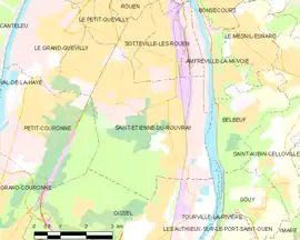 Mapa obce Saint-Étienne-du-Rouvray Mapa obce Saint-Étienne-du-Rouvray
| |||
| Wikimedia Commons: Saint-Étienne-du-Rouvray | |||
| Webová stránka: http://www.ville-saintetiennedurouvray.fr | |||
| Portály, ktorých súčasťou je táto stránka: | |||

Poloha
Mesto má rozlohu 18,25 km². Najvyšší bod je položený 87 m n. m. a najnižší bod 3 m n. m.[1]
Obyvateľstvo
Počet obyvateľov je 28 118 (2011)[2].
Nasledujúci graf zobrazuje vývoj počtu obyvateľov v meste.
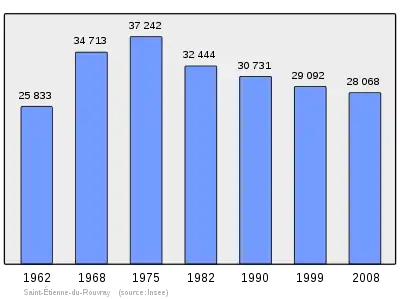
Zdroje: INSEE[3]
Partnerské mestá


Referencie
- Répertoire Géographique des Communes [online]. Institut national de l'information géographique et forestière (IGN). Dostupné online. (po francúzsky)
- Populations légales 2009 [online] Institut national de la statistique et des études économiques (Insee). Dostupné online. (po francúzsky)
- Résultat du recensement de la population 2008 [online] Institut national de la statistique et des études économiques (Insee). Dostupné online. (po francúzsky)
This article is issued from Wikipedia. The text is licensed under Creative Commons - Attribution - Sharealike. Additional terms may apply for the media files.