La Ferté-Alais (kantón)
La Ferté-Alais je francúzsky kantón v departemente Essonne v regióne Île-de-France. Vznikol 22. júla 1967.
| La Ferté-Alais | |||
| kantón | |||
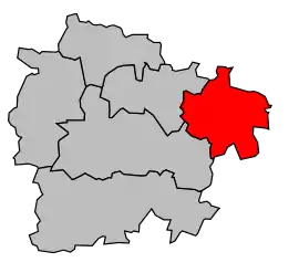 Kantón na mape obvodu Étampes | |||
| Štát | |||
|---|---|---|---|
| Región | Île-de-France | ||
| Departement | Essonne | ||
| Obvod | Étampes | ||
| Súradnice | 48°28′13″S 2°21′02″V | ||
| Správne sídlo | La Ferté-Alais | ||
| Rozloha | 110,22 km² (11 022 ha) | ||
| Obyvateľstvo | 24 306 (2011) [1] | ||
| Hustota | 220,52 obyv./km² | ||
| Časové pásmo | SEČ (UTC+1) | ||
| - letný čas | SELČ (UTC+2) | ||
| INSEE | 9111 | ||
| Počet obcí | 12 | ||
| Portál, ktorého súčasťou je táto stránka: | |||
Zloženie kantónu
| Obec | Počet obyvateľov (2008) |
PSČ | INSEE |
|---|---|---|---|
| Baulne | 1345 | 91590 | 91 1 11 047 |
| Boissy-le-Cutté | 1319 | 91590 | 91 1 11 080 |
| Boutigny-sur-Essonne | 3096 | 91820 | 91 1 11 099 |
| Cerny | 3233 | 91590 | 91 1 11 129 |
| D'Huison-Longueville | 1362 | 91590 | 91 1 11 198 |
| Guigneville-sur-Essonne | 954 | 91590 | 91 1 11 293 |
| Itteville | 6440 | 91760 | 91 1 11 315 |
| La Ferté-Alais | 4006 | 91590 | 91 1 11 232 |
| Mondeville | 666 | 91590 | 91 1 11 412 |
| Orveau | 203 | 91590 | 91 1 11 473 |
| Vayres-sur-Essonne | 910 | 91820 | 91 1 11 639 |
| Videlles | 655 | 91890 | 91 1 11 654 |
Referencie
- Populations légales 2011 (xls, 8,12 MB)
Zdroj
Tento článok je čiastočný alebo úplný preklad článku Kanton La Ferté-Alais na českej Wikipédii.

This article is issued from Wikipedia. The text is licensed under Creative Commons - Attribution - Sharealike. Additional terms may apply for the media files.