Villeneuve-sur-Fère
Villeneuve-sur-Fère je francúzska obec, ktorá sa nachádza v departemente Aisne, v regióne Pikardia.
| Villeneuve-sur-Fère | |||
| obec | |||
 | |||
| Štát | |||
|---|---|---|---|
| Región | Pikardia | ||
| Departement | Aisne | ||
| Súradnice | 49°10′39″S 3°28′30″V | ||
| Najvyšší bod | |||
| - výška | 226 m n. m. | ||
| Najnižší bod | |||
| - výška | 118 m n. m. | ||
| Rozloha | 10,3 km² (1 030 ha) | ||
| Obyvateľstvo | 296 | ||
| Hustota | 28,74 obyv./km² | ||
| Časové pásmo | SEČ (UTC+1) | ||
| - letný čas | SELČ (UTC+2) | ||
| PSČ | 02130 | ||
| INSEE | 02806 | ||
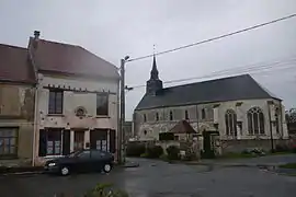
 Poloha obce Villeneuve-sur-Fère Poloha obce Villeneuve-sur-Fère
| |||
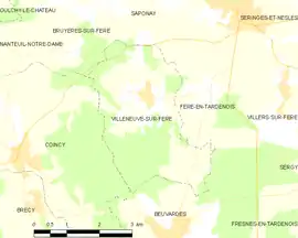 Mapa obce Villeneuve-sur-Fère Mapa obce Villeneuve-sur-Fère
| |||
| Wikimedia Commons: Villeneuve-sur-Fère | |||
| Webová stránka: http://www.communes.com/picardie/aisne/villeneuve-sur-fere_02130/ | |||
| Portály, ktorých súčasťou je táto stránka: | |||
Poloha obce
Villeneuve-sur-Fère má rozlohu 10,3 km². Najvyšší bod je položený 226 m n. m. a najnižší bod 118 m n. m.[1]
Obyvateľstvo
Villeneuve-sur-Fère má 296 obyvateľov (2009)[2].
Graf vývoja obyvateľstva:
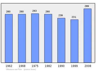
Zdroje: INSEE[3]
Referencie
- Répertoire Géographique des Communes [online]. Institut national de l'information géographique et forestière (IGN). Dostupné online. (po francúzsky)
- Populations légales 2009 [online] Institut national de la statistique et des études économiques (Insee). Dostupné online. (po francúzsky)
- Résultat du recensement de la population 2008 [online] Institut national de la statistique et des études économiques (Insee). Dostupné online. (po francúzsky)
Pozri aj
This article is issued from Wikipedia. The text is licensed under Creative Commons - Attribution - Sharealike. Additional terms may apply for the media files.