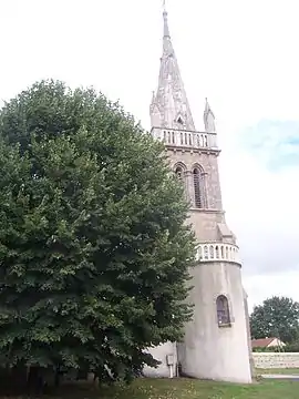
Thil-sur-Arroux
Thil-sur-Arroux je francúzska obec, ktorá sa nachádza v departemente Saône-et-Loire, v regióne Burgundsko.
| Thil-sur-Arroux | |||
| obec | |||
 | |||
| Štát | |||
|---|---|---|---|
| Región | Burgundsko | ||
| Departement | Saône-et-Loire | ||
| Obvod | Autun | ||
| Kantón | Saint-Léger-sous-Beuvray | ||
| Súradnice | 46°48′5″S 4°5′42″V | ||
| Najvyšší bod | |||
| - výška | 472 m n. m. | ||
| Najnižší bod | |||
| - výška | 261 m n. m. | ||
| Rozloha | 13,44 km² (1 344 ha) | ||
| Obyvateľstvo | 149 | ||
| Hustota | 11,09 obyv./km² | ||
| Časové pásmo | SEČ (UTC+1) | ||
| - letný čas | SELČ (UTC+2) | ||
| PSČ | 71190 | ||
| INSEE | 71537 | ||
 Poloha obce Thil-sur-Arroux Poloha obce Thil-sur-Arroux
| |||
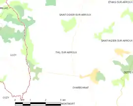 Mapa obce Thil-sur-Arroux Mapa obce Thil-sur-Arroux
| |||
| Wikimedia Commons: Thil-sur-Arroux | |||
| Portály, ktorých súčasťou je táto stránka: | |||
Poloha
Obec má rozlohu 13,44 km². Najvyšší bod je položený 472 m n. m. a najnižší bod 261 m n. m.[1]
Obyvateľstvo
Počet obyvateľov obce je 149 (2011)[2].
Nasledujúci graf zobrazuje vývoj počtu obyvateľov v obci.
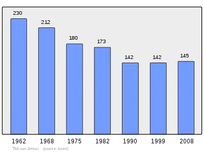
Zdroje: INSEE[3]
Referencie
- Répertoire Géographique des Communes [online]. Institut national de l'information géographique et forestière (IGN). Dostupné online. (po francúzsky)
- Populations légales 2009 [online] Institut national de la statistique et des études économiques (Insee). Dostupné online. (po francúzsky)
- Résultat du recensement de la population 2008 [online] Institut national de la statistique et des études économiques (Insee). Dostupné online. (po francúzsky)
This article is issued from Wikipedia. The text is licensed under Creative Commons - Attribution - Sharealike. Additional terms may apply for the media files.