Penne (Tarn)
Penne je francúzska obec, ktorá sa nachádza v departemente Tarn, v regióne Midi-Pyrénées.
| Penne | |||
| obec | |||
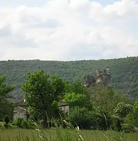 Hrad | |||
|
|||
| Štát | |||
|---|---|---|---|
| Región | Midi-Pyrénées | ||
| Departement | Tarn | ||
| Rieka | Aveyron | ||
| Súradnice | 44°4′38″S 1°43′49″V | ||
| Najvyšší bod | |||
| - výška | 489 m n. m. | ||
| Najnižší bod | |||
| - výška | 93 m n. m. | ||
| Rozloha | 64,04 km² (6 404 ha) | ||
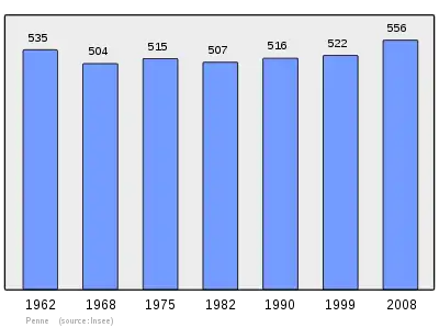
| Obyvateľstvo | 559 | ||
| Hustota | 8,73 obyv./km² | ||
| Časové pásmo | SEČ (UTC+1) | ||
| - letný čas | SELČ (UTC+2) | ||
| PSČ | 81140 | ||
| INSEE | 81206 | ||
 Poloha obce Penne Poloha obce Penne
| |||
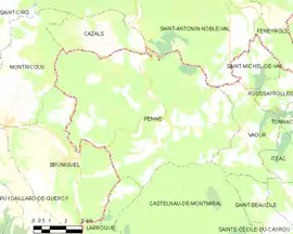 Mapa obce Penne Mapa obce Penne
| |||
| Wikimedia Commons: Penne (Tarn) | |||
| Portály, ktorých súčasťou je táto stránka: | |||
.svg.png.webp)
Polohopis
Penne má rozlohu 64,04 km². Najvyšší bod je položený 489 m n. m. a najnižší bod 93 m n. m.[1] pri rieke Aveyron.
Susedné obce:
Herri batzuen distantzia eta kokapen erlatiboa
Referencie
- Répertoire Géographique des Communes [online]. Institut national de l'information géographique et forestière (IGN). Dostupné online. (po francúzsky)
- Populations légales 2009 [online] Institut national de la statistique et des études économiques (Insee). Dostupné online. (po francúzsky)
- Résultat du recensement de la population 2008 [online] Institut national de la statistique et des études économiques (Insee). Dostupné online. (po francúzsky)
This article is issued from Wikipedia. The text is licensed under Creative Commons - Attribution - Sharealike. Additional terms may apply for the media files.