Bretoncelles
Bretoncelles je francouzská obec v departementu Orne v regionu Normandie. Žije zde přibližně 1 500[1] obyvatel.
| Bretoncelles | |
|---|---|
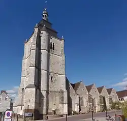 Kostel Saint-Pierre | |
 znak | |
| Poloha | |
| Souřadnice | 48°25′52″ s. š., 0°53′11″ v. d. |
| Nadmořská výška | 120–266 m n. m. |
| Stát | |
| Region | Normandie |
| Departement | Orne |
| Arrondissement | Mortagne-au-Perche |
| Kanton | Bretoncelles |
 Bretoncelles | |
| Rozloha a obyvatelstvo | |
| Rozloha | 40,2 km² |
| Počet obyvatel | 1 478 (2019)[1] |
| Hustota zalidnění | 36,8 obyv./km² |
| Správa | |
| Oficiální web | www |
| PSČ | 61110 |
| INSEE | 61061 |
| Některá data mohou pocházet z datové položky. | |
Geografie
Obec leží na jihovýchodě departementu Orne u jeho hranic s departementem Eure-et-Loir, tedy i u hranic regionu Normandie s regionem Centre-Val de Loire.
Sousední obce
 |
Moutiers-au-Perche |
La Madeleine-Bouvet |
Le Pas-Saint-l'Homer Meaucé (Eure-et-Loir) |
|
| Rémalard en Perche | Vaupillon (Eure-et-Loir) | |||
| Saint-Germain-des-Grois |
Sablons sur Huisne |
Saint-Victor-de-Buthon (Eure-et-Loir) |
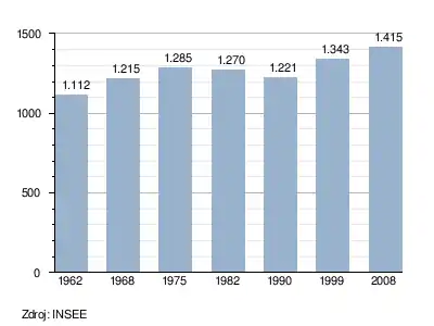
Vývoj počtu obyvatel
Odkazy
Reference
- Populations légales 2019. 12. ledna 2022. Dostupné online.
Související články
Externí odkazy
 Obrázky, zvuky či videa k tématu Bretoncelles na Wikimedia Commons
Portály: Francie | Geografie
This article is issued from Wikipedia. The text is licensed under Creative Commons - Attribution - Sharealike. Additional terms may apply for the media files.